Since its establishment in 1974, the Region 2 Planning Commission has been active in the economic development of the Region. The R2PC has assisted local units of government with the creation of economic development tools such as overall economic development plans, TIFA districts, master plans, infrastructure improvements, and development of proposals for economic development projects.
The U.S. Economic Development Administration (EDA) established the R2PC as an Economic Development District (EDD) for the Region 2 area (i.e., Hillsdale, Jackson and Lenawee counties) in 2013. That status provides funding for the R2PC’s economic development program through the EDA Partnership Planning grants and makes the entire Region 2 Area eligible to apply for other federal grants for local economic development projects. A primary focus of the EDD is maintaining an up-to-date Comprehensive Economic Development Strategy (CEDS).

Downtown Jackson Cruise-In
Comprehensive Economic Development Study (CEDS)
The CEDS is a regional approach to economic development planning and is an Economic Development Administration (EDA) requirement. The 2021-2025 edition of the Region 2 Planning Commission Comprehensive Development Strategy was developed by a Steering Committee facilitated by R2PC staff approved by the Full Board on __________________.
The CEDS includes: a description of the Region 2 Area, including socioeconomic performance monitoring; a further refined analysis of socioeconomic conditions through a SWOT (Strengths, Weaknesses, Opportunities, and Threats) analysis; a Mission Statement; and an Action Plan, including Goals, Strategies with corresponding Performance Measures which address each Goal, and a broad listing of economic development Project Types needed in the Region 2 area.
CEDS Mission Statement
To produce an environment that encourages the creation of jobs, promotes education, fosters community development (including placemaking, quality of life, and infrastructure), and advances business development to compete in a global environment.
CEDS Goals & Strategies
The CEDS also lists four goals intended to address the Region’s economic development needs:
- Encourage collaborative and economic partnerships to promote innovation and entrepreneurship.
- Provide opportunities to support globally competitive business environment strategies.
- Expand post-secondary educational and workforce development opportunities to retain and attract talent
- Diversify the economy.
Strategies with corresponding Performance Measures were also identified to address each goal.
CEDS Endorsed Project Types
- Commercial, Industrial, and Entrepreneurial Investments
- New/Expanding Research and Development Facilities and High-Tech Industries
- New/Expanding Education Facilities and Innovative Equipment Acquisition
- Public and Multi-Modal Transportation
- Roadway Network Maintenance/Improvements
- Expansion/Maintenance of Public Transportation Services
- Freight — Rail/Air/Port Maintenance/Improvements
- Investment in Energy and Renewable Energy
- Infrastructure Improvements
- Waste Management and Treatment (e.g., Water, Sewer, Solid Waste)
- Utility Restoration, Improvement, and Access (including Broadband)
- Provision of Other Municipal (including County) Services
- Place Making, Culture, Recreation and Tourism Efforts
- New Mixed-Use Developments
- Business and Technology Incubator/Accelerator
- Agriculture, including Value-Added Processing, and the Local Food Movement
- Water/Natural Resources
- Education/Workforce Training
- Increased Housing Options (e.g., the ‘missing middle’)
- Health Care, including Medical Services, and Wellness
- Asset Mapping
- Professional Service Industries (e.g., engineering, architects, accountants, lawyers)
Existing Land Use Patterns & Major Community Facilities
A goal (and associated strategies and actions) of the 2017-2021 edition of the Region 2 Planning Commission Comprehensive Economic Development Strategy (CEDS) is the identification and mapping of cultural and recreational resources.
A first step in identifying major community facilities (i.e., cultural and recreational resources) is to map existing land use patterns utilizing property assessment categories (i.e., existing land use). Many cultural and recreational resources have an exempt status, making them easier to identify. It was further noted that the property assessment data can also be utilized by counties and municipalities as they create economical and up-to-date existing land use maps for inclusion in master plans and other planning documents. This following reports provide more detailed information on existing land use patterns and cultural and recreational resources found in in the entire Region 2 Area as well as for each of the three counties:
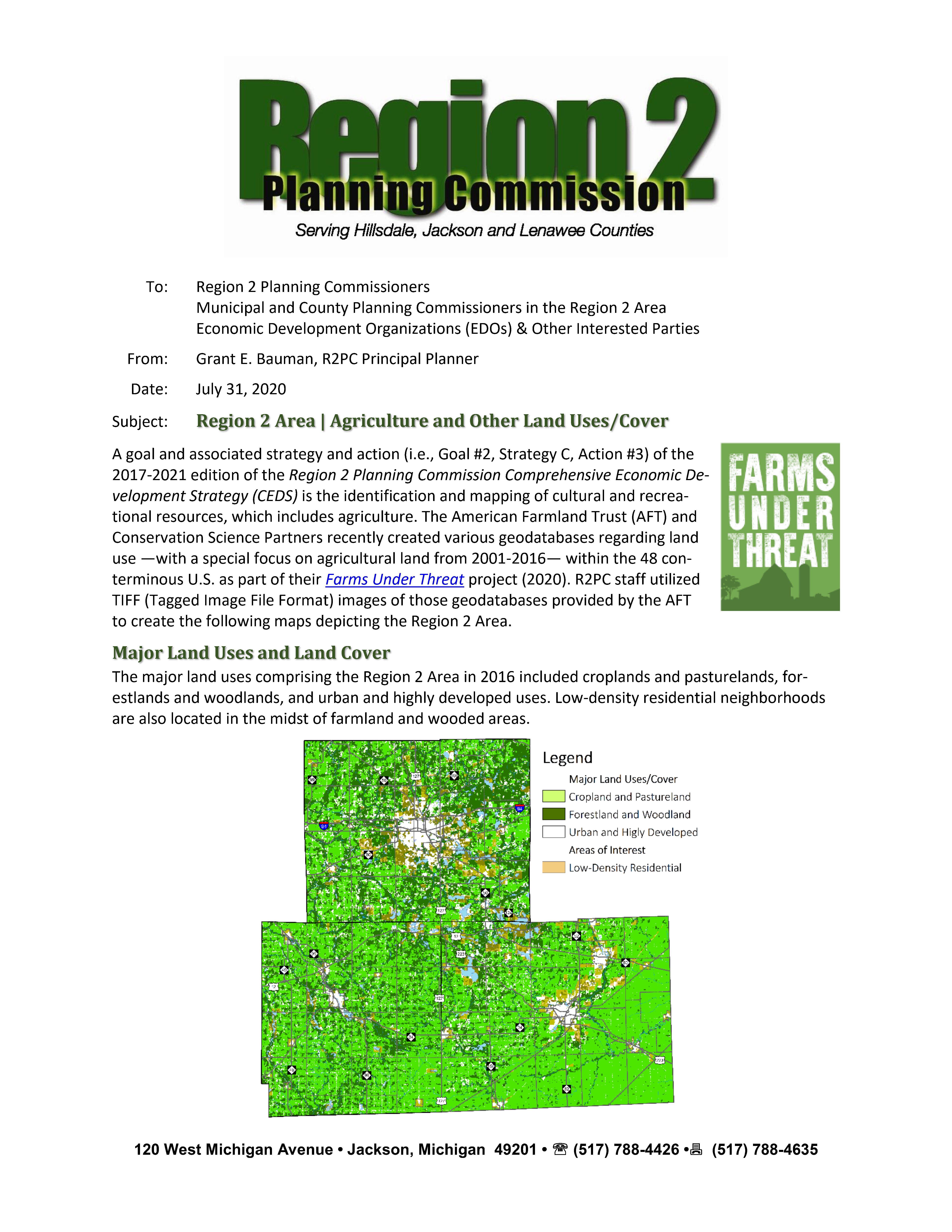
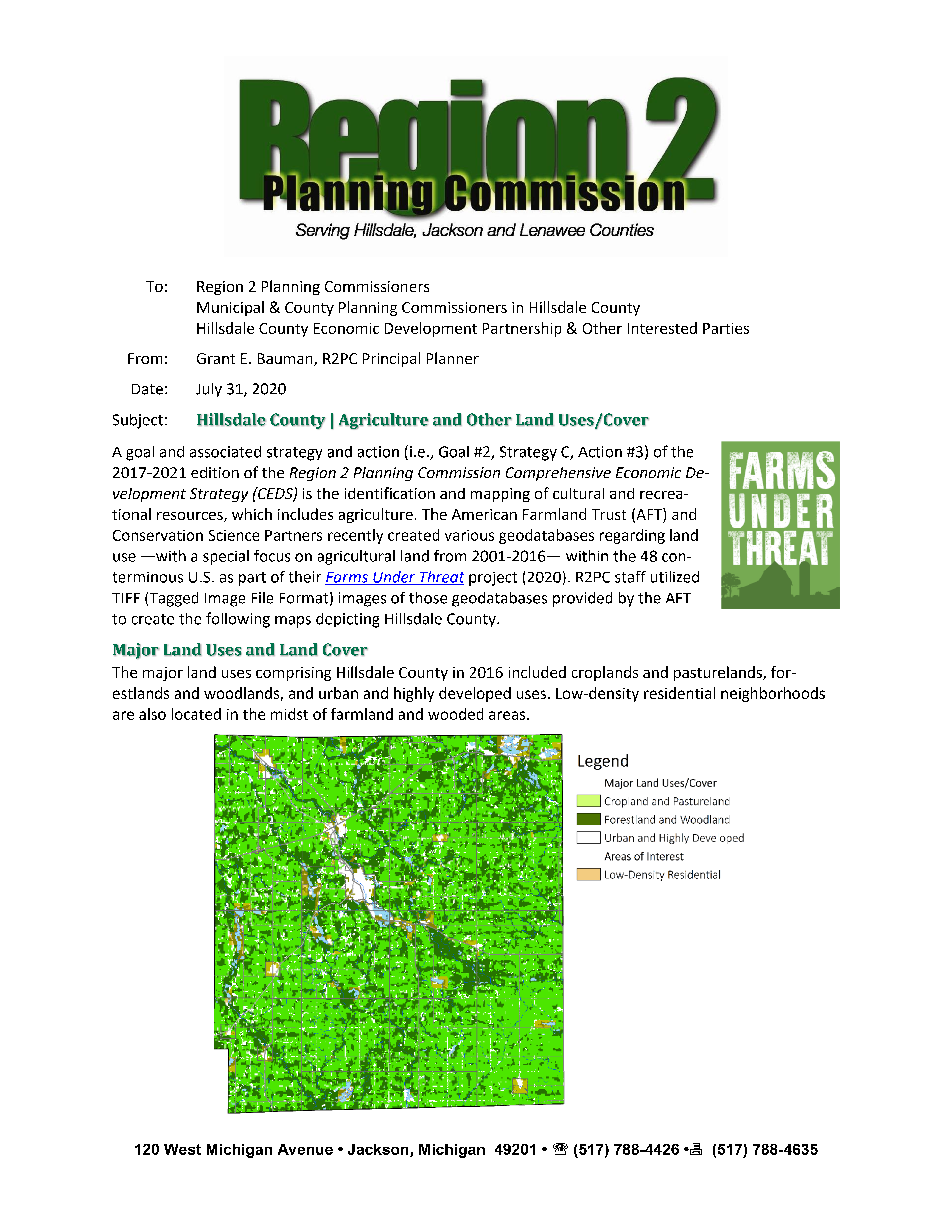
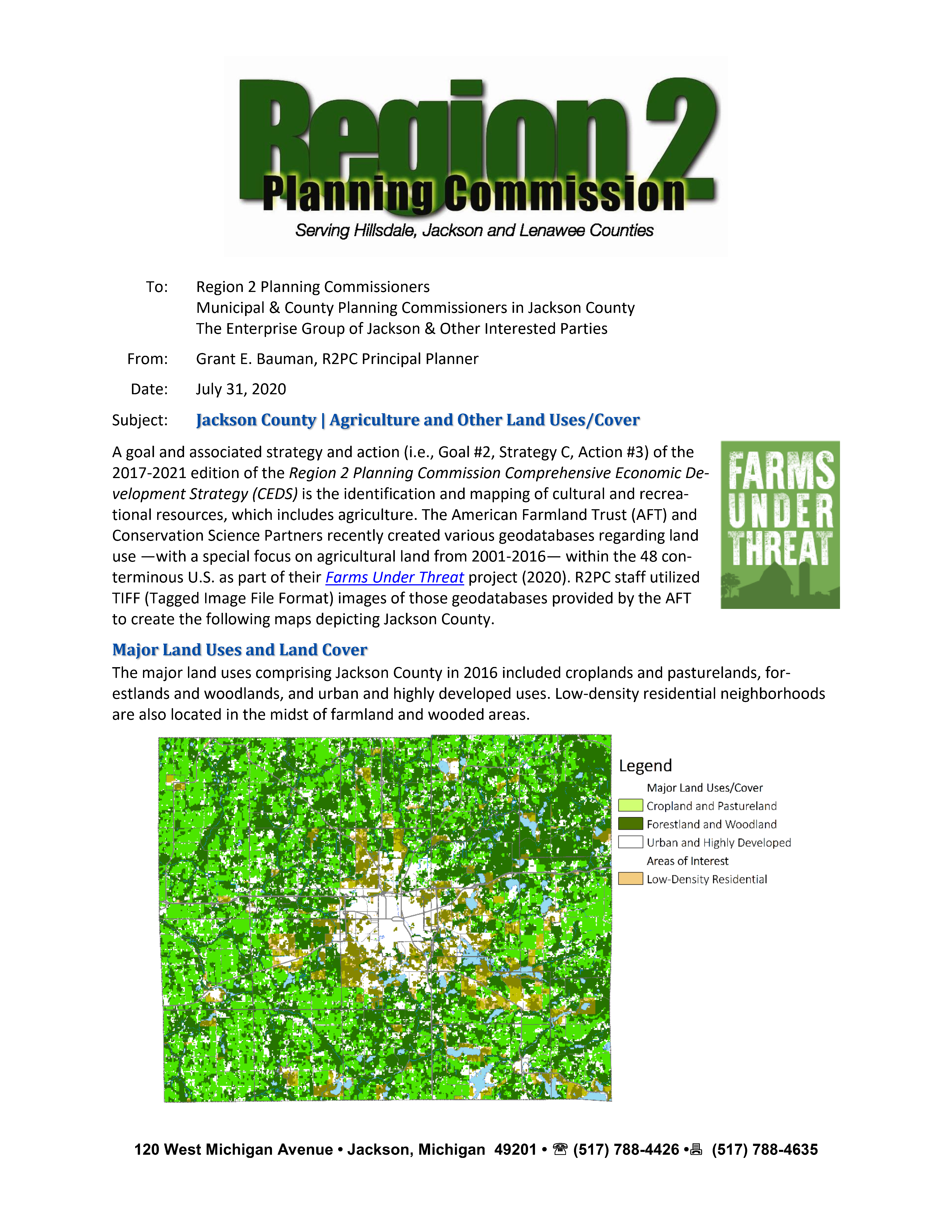
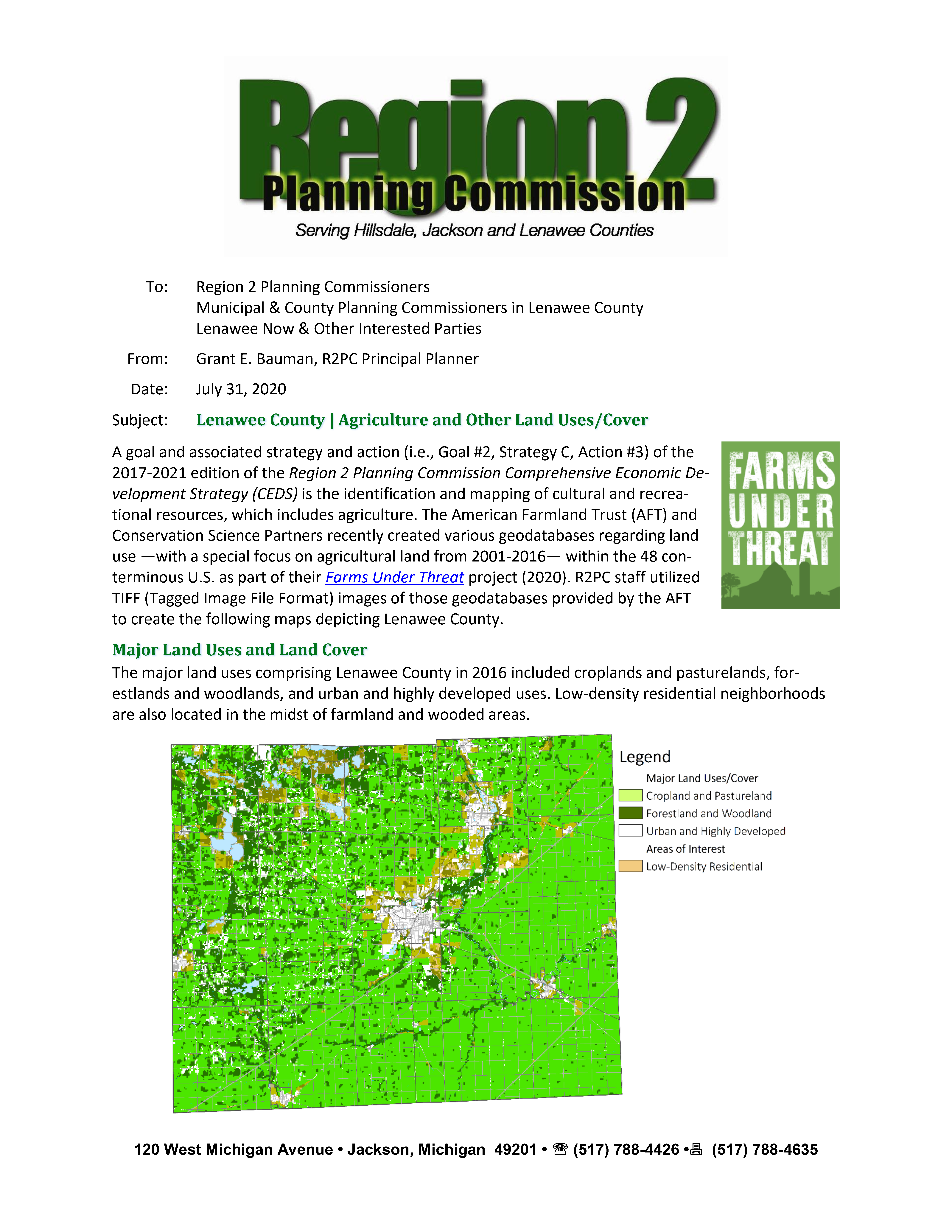
Agriculture and Other Land Uses and Land Cover
A goal and associated strategy and action (i.e., Goal #2, Strategy C, Action #3) of the 2017-2021 edition of the Region 2 Planning Commission Comprehensive Economic Development Strategy (CEDS) is the identification and mapping of cultural and recreational resources, which includes agriculture. The American Farmland Trust (AFT) and Conservation Science Partners recently created various geodatabases regarding land use —with a special focus on agricultural land from 2001-2016— within the 48 conterminous U.S. as part of their Farms Under Threat project (2020). R2PC staff utilized TIFF (Tagged Image File Format) images of those geodatabases provided by the AFT to create the following maps depicting the Region 2 Area as well as each of its 3 counties.
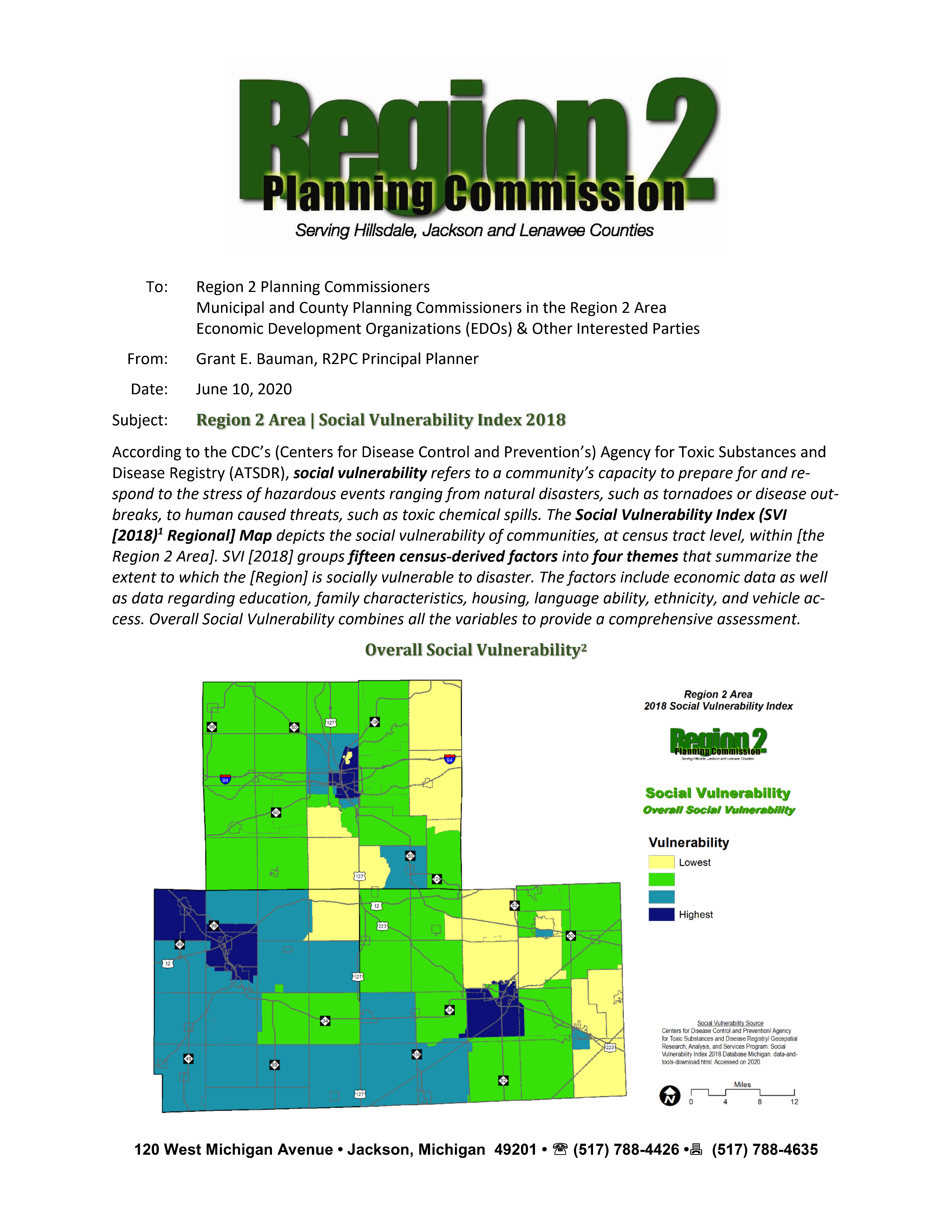
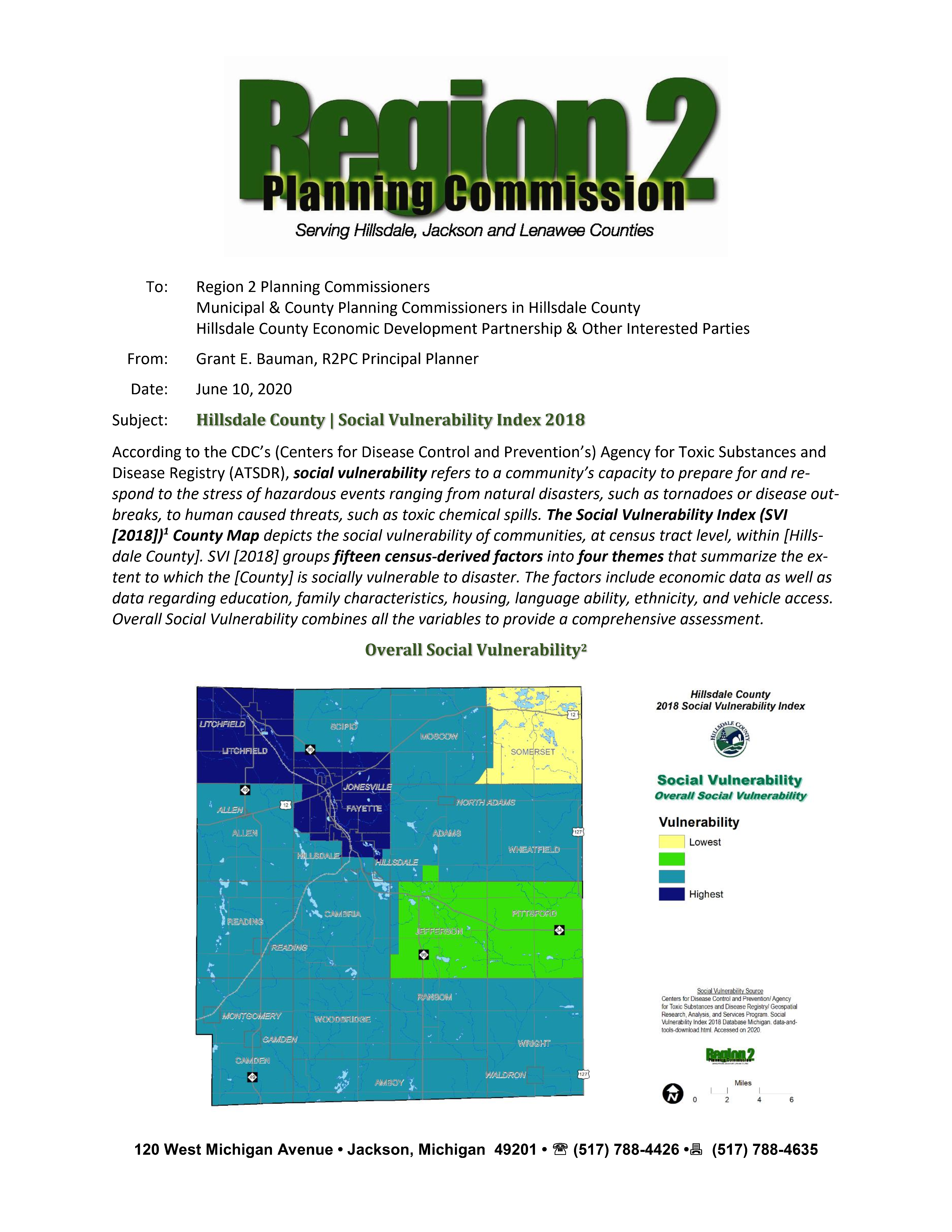
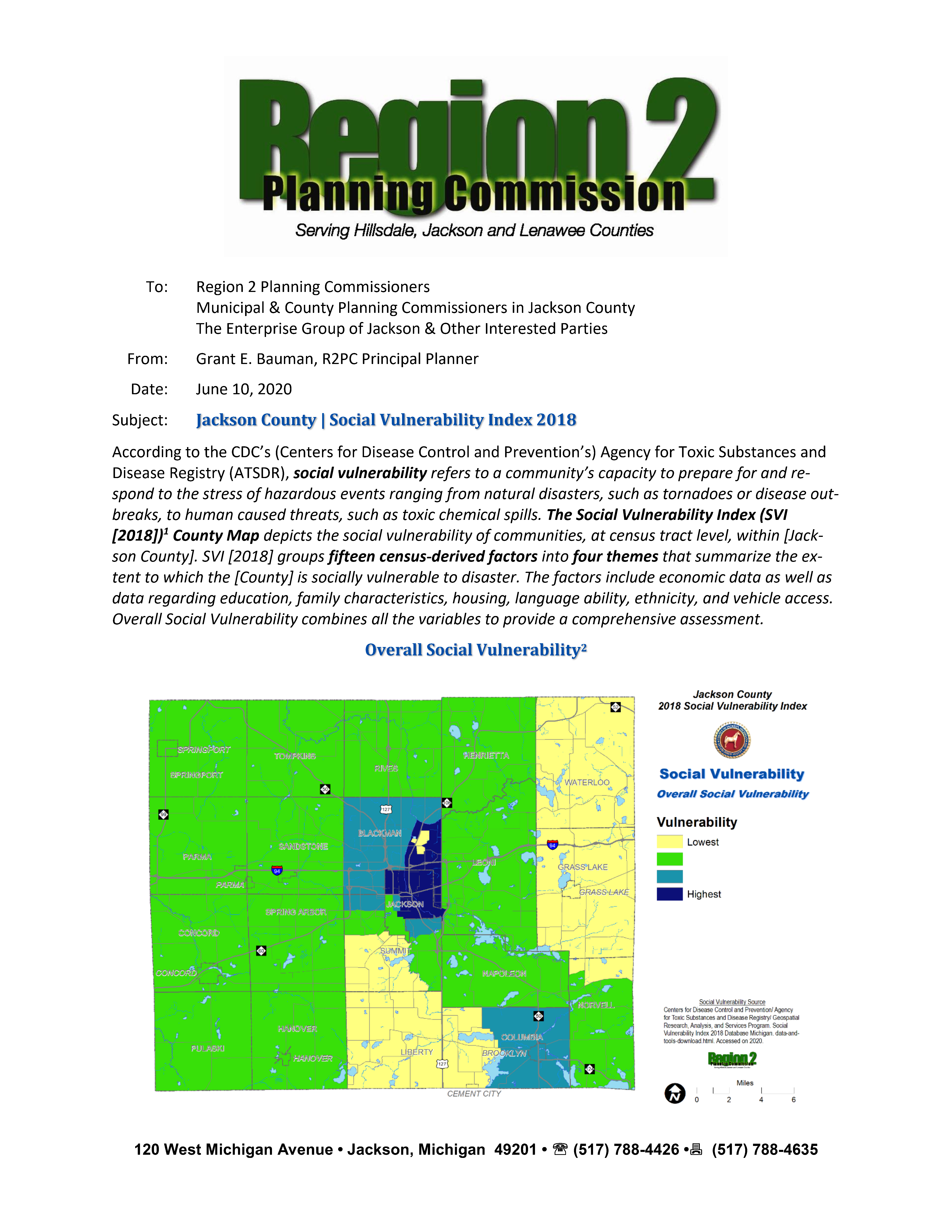
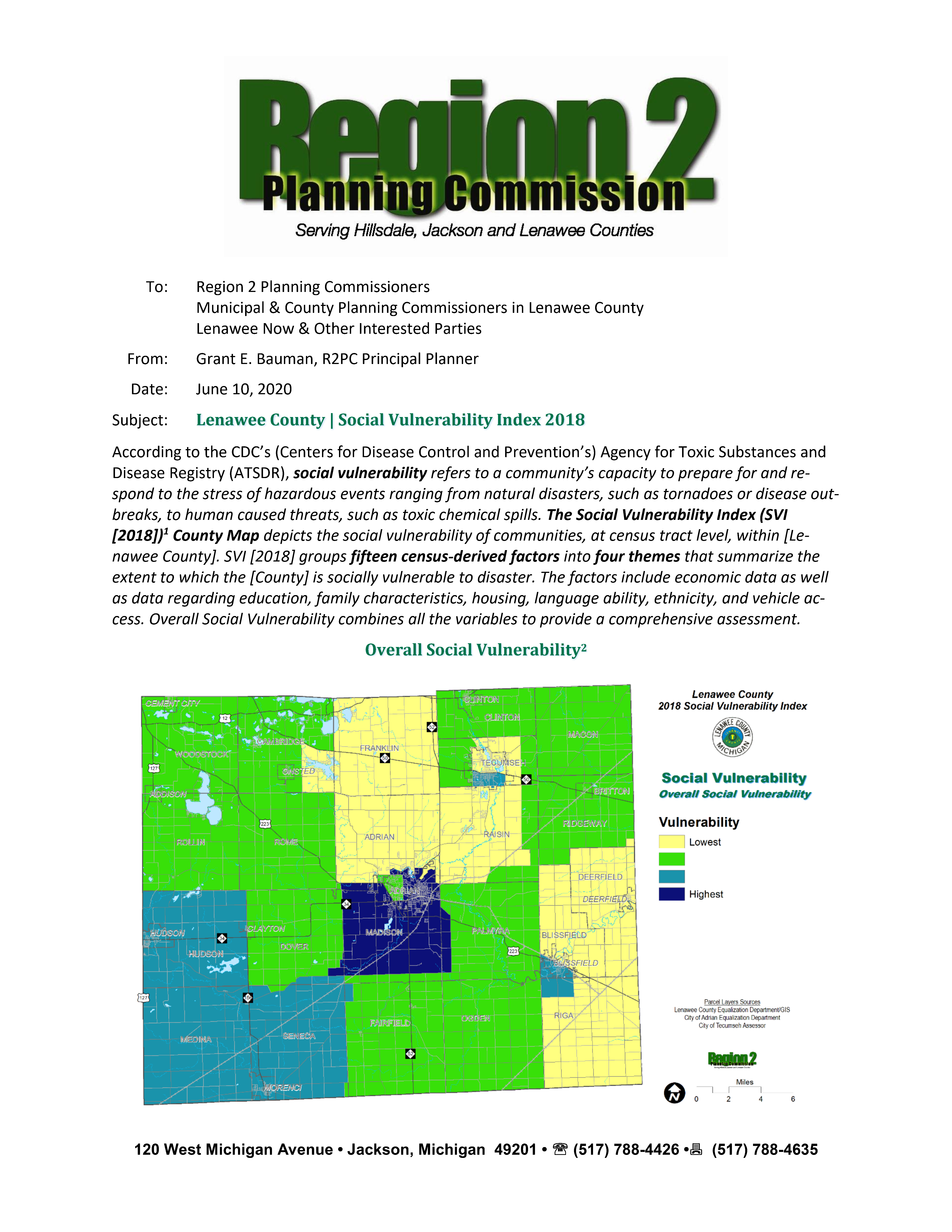
Social Vulnerability Index (SVI)
The COVID-19 Pandemic reminds us that disasters of all types may have lasting impacts on the economy and society in general. Some people and households are more vulnerable to those impacts than others and need assistance in order to recover and become more resilient in the future. This vulnerability extends to the neighborhoods and municipalities in which they are grouped together. The CDC’s (Centers for Disease Control and Prevention’s) Agency for Toxic Substances and Disease Registry (ATSDR) defines social vulnerability as “a community’s capacity to prepare for and respond to the stress of hazardous events ranging from natural disasters, such as tornadoes or disease outbreaks, to human caused threats, such as toxic chemical spills.” Its Social Vulnerability Index “depicts the social vulnerability of communities, at census tract level”, by grouping “fifteen census-derived factors into four themes that summarize the extent to which an area is socially vulnerable to disaster” (i.e., “economic data as well as data regarding education, family characteristics, housing, language ability, ethnicity, and vehicle access”). The CDC’s “Overall Social Vulnerability combines all the variables to provide a comprehensive assessment.” Please refer to the CDC’s Social Vulnerability Index webpage for more background information. The following reports provide information on the social vulnerability of the Region 2 Area in 2018 as well as for each of the three counties:
